
| Data and Documentation | Chronology and News | Program Status | Publications | Related Data and Resources | Contact Points |
ICOADS Web information page (Wednesday, 25-Jul-2012 18:06:44 UTC):
Chinese/Global Ocean Data Archeology and Rescue (GODAR) Ships (deck 781) (by ESRL)
As part of the Global Ocean Data Archeology and Rescue (GODAR) project, surface marine ship data were digitized in China. The data were received at NCAR (http://rda.ucar.edu/datasets/ds541.4/) from NCDC on CD-ROM.
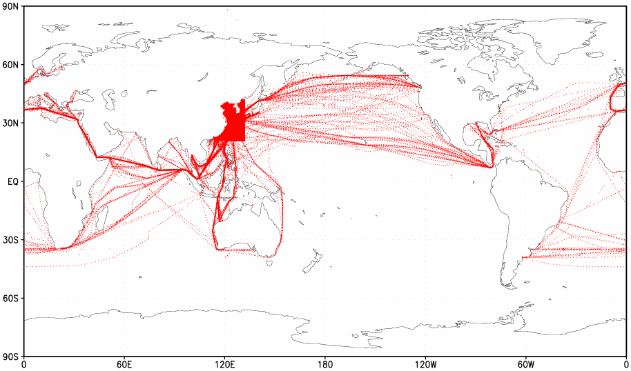
Figure 1. Coverage for the period of record 1968-93 (414,409 unique output reports).
IMMA supplemental data and conversion to other IMMA elements
MARINE METEOROLOGICAL OBSERVATION DATA FORMAT DESCRIPTION  ************************************************************************************
Po.No. element description
************************************************************************************
Po.No. element description  ------------------------------------------------------------------------------------
1 - 4 ship code 4 characters
------------------------------------------------------------------------------------
1 - 4 ship code 4 characters  5 - 8 year (GMT) 1900-present
  9 -10 month 1-12
  11 -12 day 1-31
  13 -14 hour 0-23
  15 -16 latitude degree 0-90
  17 -20 latitude minute 0.0-59.9
21 -21 hemisphere(N or S)
22 -24 longitude degree 0-180
17 -20 latitude minute 0.0-59.9
21 -21 hemisphere(N or S)
22 -24 longitude degree 0-180  25 -28 longitude minute 0.0-59.9
29 -29 hemisphere(E or W)
30 -32 voyage direction 1-360, 888 for unknown and 999 for missing
25 -28 longitude minute 0.0-59.9
29 -29 hemisphere(E or W)
30 -32 voyage direction 1-360, 888 for unknown and 999 for missing  33 -36 voyage speed knots, -9.9 for missing, -8.8 for unknown
  37 -38 total cloud amount 0-11, // for unknown,blank for missing
  0:clear or less then 1/20
1: 1/10
2: 2/10
3: 3/10
4: 4/10
5: 5/10
6: 6/10
7: 7/10
8: 8/10
9: 9/10
10: 10/10
11: The celestial dome is almost entirely covered,
but with a few chinks.
39 -40 lower cloud amount 0-11, // for unknown,blank for missing
0:clear or less then 1/20
1: 1/10
2: 2/10
3: 3/10
4: 4/10
5: 5/10
6: 6/10
7: 7/10
8: 8/10
9: 9/10
10: 10/10
11: The celestial dome is almost entirely covered,
but with a few chinks.
39 -40 lower cloud amount 0-11, // for unknown,blank for missing  41 -44 type of high cloud Ci Cs Cc
45 -48 type of middle cloud As Ac
49 -52 type of low cloud Cu Cb Sc St Ns Fn
'////' for unknown
' ' for no cloud
53 -56 cloud height 0000-9000, '8888' for unknown,'9999' for missing
41 -44 type of high cloud Ci Cs Cc
45 -48 type of middle cloud As Ac
49 -52 type of low cloud Cu Cb Sc St Ns Fn
'////' for unknown
' ' for no cloud
53 -56 cloud height 0000-9000, '8888' for unknown,'9999' for missing  57 -58 visibility 90-99 blank and '//' for missing or unknown
  90:<50m
91:50m-200m
92:200m-500m
93:500m-1km
94:1-<2km
95:2-<4km
96:4-<10km
97:10-<20km
98:20-<50km
99:>=50km
59 -60 present weather
90:<50m
91:50m-200m
92:200m-500m
93:500m-1km
94:1-<2km
95:2-<4km
96:4-<10km
97:10-<20km
98:20-<50km
99:>=50km
59 -60 present weather  the following codes mean:
00: no follow weather phenomenon
05: haze
10: mist
17: thunderstorm
19: squall
45: fog
50: drizzle
60: rain
69: rain or drizzle and snow
70: snow
80: rain shower
89: hail shower
95: thunderstorm with rain and/or snow
The other codes use WMO 4677.
blank for unknown and '//'for missing
61 -61 past weather 0-9
the following codes mean:
00: no follow weather phenomenon
05: haze
10: mist
17: thunderstorm
19: squall
45: fog
50: drizzle
60: rain
69: rain or drizzle and snow
70: snow
80: rain shower
89: hail shower
95: thunderstorm with rain and/or snow
The other codes use WMO 4677.
blank for unknown and '//'for missing
61 -61 past weather 0-9  62 -62 2nd past weather 0-9
  63 -66 wave height 0.0-50.0 99.9 for missing and 88.8 for unknown
  67 -69 swell direction same as wind direction
  70 -73 swell height meter
  74 -74 wind indicator 0,1 no use
75 -77 wind direction 0-359,361 for calm and 362 for variable
74 -74 wind indicator 0,1 no use
75 -77 wind direction 0-359,361 for calm and 362 for variable  78 -81 wind speed meters per second
  82 -86 air temp. celsius degree
  -99.9 for missing and -88.8 for unknown
87 -91 wet bulb temp. celsius degree
-99.9 for missing and -88.8 for unknown
87 -91 wet bulb temp. celsius degree  -99.9 for missing and -88.8 for unknown
92 -97 sea level pressure hPa
-99.9 for missing and -88.8 for unknown
92 -97 sea level pressure hPa  9999.9 for missing and 8888.8 for unknown
98-102 sea surface temp. celsius degree
9999.9 for missing and 8888.8 for unknown
98-102 sea surface temp. celsius degree  103-108 salinity 99.999 for miss and 88.888 for unknown
109-109 sea luminance 0: no
1: yes
9 for missing and 8 for unknown
110-110 mark '*'
111-111 date flag '1' query
112-112 location flag
113-113 landlock flag
114-114 air temp. flag
115-115 wetbulb temp. flag
116-116 sea surface temp. flag
117-117 cloud flag
118-118 wind flag
119-119 wave flag
120-120 sea level pressure flag
121-121 weather flag
122-122 mark '*'
-------------------------------------------------------------------------------------
* GENERALLY BLANK MEANS MISSING OBSERVATION
103-108 salinity 99.999 for miss and 88.888 for unknown
109-109 sea luminance 0: no
1: yes
9 for missing and 8 for unknown
110-110 mark '*'
111-111 date flag '1' query
112-112 location flag
113-113 landlock flag
114-114 air temp. flag
115-115 wetbulb temp. flag
116-116 sea surface temp. flag
117-117 cloud flag
118-118 wind flag
119-119 wave flag
120-120 sea level pressure flag
121-121 weather flag
122-122 mark '*'
-------------------------------------------------------------------------------------
* GENERALLY BLANK MEANS MISSING OBSERVATION
Elements requiring conversion of units
- Equal ("=") signifies conversion from input unit to output unit.
- 15 -16 latitude degree, 17 -20 latitude minute, 21 -21 hemisphere(N or S)
- =[- if hemisphere=S](latitude_degree + (latitude_minute / 60.))
- 22 -24 longitude degree, 25 -28 longitude minute, 29 -29 hemisphere(E or W)
- =[360. - if hemisphere=W](longitude_degree + (longitude_minute / 60.))
- 30 -32 voyage direction
-
total 0=0 5185 1=8 26253 2=8 11824 3=8 10737 4=8 27113 5=8 23284 6=8 3715 7=8 9787 8=8 24646 9=8 326 10=8 336 11=8 27 12=8 182 13=8 67 14=8 21 15=8 112 16=8 38 17=8 39 18=8 33 19=8 81 20=8 131 21=8 46 22=8 105 23=1 69 . . . 337=7 810 338=8 598 339=8 66 340=8 285 341=8 45 342=8 63 343=8 45 344=8 59 345=8 112 346=8 44 347=8 23 348=8 59 349=8 70 350=8 210 351=8 34 352=8 66 353=8 144 354=8 55 355=8 398 356=8 87 357=8 233 358=8 179 359=8 112 360=8 453 888=9 5 - 33 -36 voyage speed
- 0.0-0.4=0, 0.5-5.4=1, 5.5-10.4=2, 10.5-15.4=3, 15.5-20.4=4, 20.5-25.4=5, 25.5-30.4=6, 30.5-35.4=7, 35.5-40.4=8, 40.5-99.9=9, -9.9=missing, -8.8=missing
- 37 -38 total cloud amount
- 0=0, 1=1, 2=2, 3=2, 4=3, 5=4, 6=5, 7=6, 8=6, 9=7, 10=8, 11=8
- 39 -40 lower cloud amount
- 0=0, 1=1, 2=2, 3=2, 4=3, 5=4, 6=5, 7=6, 8=6, 9=7, 10=8, 11=8
- 41 -44 type of high cloud
-
an inventory of this unconverted element follows
total CH //// 35367 CH CC 4942 CH CCCI 11 CH CCCS 3 CH CI 12412 CH CICC 30 CH CICS 5262 CH CS 7409 CH CSCC 11 CH CSCI 29 - 45 -48 type of middle cloud
-
an inventory of this unconverted element follows
total CM //// 34103 CM AC 24010 CM ACAC 8 CM ACAS 926 CM AS 22958 CM ASAC 12002 CM ASAS 9 - 49 -52 type of low cloud
-
an inventory of this unconverted element follows
total CL //// 37285 CL CB 1401 CL CBCU 81 CL CBFN 9 CL CBNS 147 CL CBSC 56 CL CBST 8 CL CU 36540 CL CUCB 166 CL CUFN 9 CL CUNS 129 CL CUSC 15572 CL CUST 70 CL FN 7028 CL FNCB 9 CL FNCU 2 CL FNNS 87 CL FNSC 1 CL FNST 1 CL NS 6905 CL NSCB 228 CL NSCU 200 CL NSFN 177 CL NSNS 1 CL NSSC 131 CL NSST 144 CL SC 27444 CL SCCB 63 CL SCCU 1111 CL SCFN 8 CL SCNS 109 CL SCSC 1 CL SCST 35 CL ST 19941 CL STCB 18 CL STCU 47 CL STFN 7 CL STNS 69 CL STSC 52 - 53 -56 cloud height
- 0-149=0, 150-299=1, 300-599=2, 600-999=3, 1000-1999=4, 2000-3499=5, 3500-4999=6, 5000-6499=7, 6500-7999=8, 8000-8887=9, 8888=missing, 8889-9998=9, 9999=missing
- 63 -66 wave height
-
=round(wave_height * 2)
0.0=0, 0.1=0, 0.2=0, 0.3=1, 0.4=1, 0.5=1, 0.6=1, 0.7=1, 0.8=2, ... 49.2=98, 49.3=99, 49.4=99, 49.5=99, 49.6=99, 49.7=99, 88.8=missing, 99.9=missing - 67 -69 swell direction
-
total 0=0 32172 1=36 28 2=36 32 3=36 15 4=36 13 5=1 90 6=1 17 7=1 7 8=1 29 9=1 14 10=1 3983 11=1 4 . . . 349=35 2 350=35 3370 351=35 5 352=35 7 353=35 5 354=35 8 355=36 77 356=36 6 357=36 3 358=36 7 359=36 2 360=36 4587 888=missing 25 999=missing 113 - 70 -73 swell height
-
=round(swell_height * 2)
0.0=0, 0.1=0, 0.2=0, 0.3=1, 0.4=1, 0.5=1, 0.6=1, 0.7=1, 0.8=2, ... 49.2=98, 49.3=99, 49.4=99, 49.5=99, 49.6=99, 49.7=99, 88.8=missing, 99.9=missing - 75 -77 wind direction
-
total 0=361 5324 1=1 500 2=2 205 3=3 244 4=4 308 5=5 253 6=6 248 7=7 247 8=8 277 9=9 272 10=10 10762 11=11 255 . . . 349=349 241 350=350 9350 351=351 267 352=352 260 353=353 292 354=354 248 355=355 307 356=356 276 357=357 250 358=358 364 359=359 242 360=360 16005 361=361 12 362=362 1 888=missing 1
TI time indicator = 0 = nearest whole hour
LI lat/lon indicator = 4 = degrees and minutes
II id indicator = 1 = ship, OSV, or ice station call sign
DI wind direction indicator = 5 = 360-point compass
WI wind speed indicator = 1 = meter per second, measured
IT indicator for temperatures = 0 = degrees Celsius and tenths
DCK deck = 781 = Chinese/Global Ocean Data Archeology and Rescue (GODAR) Ships
SID source ID = 143 = Chinese/Global Ocean Data Archeology and Rescue (GODAR) Ships
PT platform type = 5 = ship
Assessments of data quality
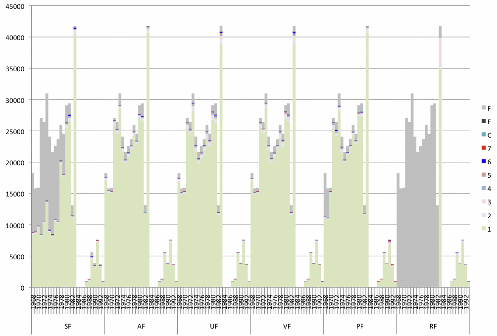
Figure 2. Number of reports per year plotted separately to show the trimming flag value, within those reports, for these variables: SF = sea surface temperature, AF = air temperature, UF and VF = wind U and V components, PF = sea level pressure, RF = relative humidity. The trimming flags are defined as follows, where a1 is the individual observation under scrutiny, g is the smoothed median, and s1 and s5 are the smoothed lower and upper median deviation:
F = data missing or not computable
E = data unusable (SF, AF, and PF, only)
C = limits missing (ocean/coastal box)
7 = greater than 4.5 sigma upper limit (a1 > g + 4.5*s5)
6 = less than 4.5 sigma lower limit (a1 < g - 4.5*s1)
5 = greater than 3.5 sigma upper limit (g + 3.5*s5 < a1 <= g + 4.5*s5)
4 = less than 3.5 sigma lower limit (g - 4.5*s1 <= a1 < g - 3.5*s1)
3 = greater than 2.8 sigma upper limit (g + 2.8*s5 < a1 <= g + 3.5*s5)
2 = less than 2.8 sigma lower limit (g - 3.5*s1 <= a1 < g - 2.8*s1)
1 = within 2.8 sigma limits (g - 2.8*s1 <= a1 <= g + 2.8*s5)
[Documentation and Software][Translation information]
U.S. National Oceanic and Atmospheric Administration hosts the icoads website privacy disclaimer
Document maintained by icoads@noaa.gov
Updated: Jul 25, 2012 18:06:44 UTC
http://www.icoads.noaa.gov/godar.html