
| Data and Documentation | Chronology and News | Program Status | Publications | Related Data and Resources | Contact Points |
ICOADS Web information page (Wednesday, 25-Jul-2012 18:06:59 UTC):
US Navy Hourlies (deck 117; 1951-64) (by ESRL)
1. Introduction
Deck 117 forms a significant (approximately 3M reports) and largely untapped data source for ICOADS, which (according to AWS-WB 1964) is an extension of deck 110 (US Navy Marine); however, the original card deck formats for 110 (AWS-WB 1958) and 117 are very different. Three major versions of the deck 117 data have been located and converted into IMMA format, which can be distinguished by source ID (SID):
SID = 140: US Navy Hourlies: Deck 117 in TD-1100 format (2,506,125 input reports; 2,503,540 output reports): abbreviated as "TD1100" belowThe output is less than the input in each case due to the removal of exact duplicates, etc.
SID = 141: US Navy Hourlies: Original card deck 117 format (from FOSDIC) (2,951,933 input reports; 2,948,937 output reports): abbreviated as "FOSDIC" below
SID = 142: US Navy Hourlies: Original card deck 117 format (from DSI1117) (2,953,342 input reports; 2,948,643 output reports): abbreviated as "DSI1117" below
SIDs 141 and 142 appear to be largely identical data (specifically 99.7881% of the FOSDIC and 99.798% of the DSI1117 reports were duplicates of each other). However, the DSI1117 data (NCDC 2003) were supplied as two separate files, one described as "navy-marine-sfc-obs" and the other as "osv-ice-island" (i.e. separating out the Ocean Station Vessel [OSV] and Ice Island data). Rather than assign another SID to data from the latter file, we have made different platform type (PT) assignments to those data as explained in Figs. 3-4.
Additionally, 16K reports from deck 117 were included in COADS Release 1 (Slutz et al. 1985), with 11K retained after duplicate elimination processing, and thus form a fourth source for limited intercomparison (see Annex). We know that these data were supplied by NCDC in TD-1100 format for Release 1, because they came from the following larger TD-1100 sources (note: these deck 117 data appear to have been utilized for Release 1 primarily for Ocean Station Vessels):
SID = 1: Atlas (20 reports)Also we note that some deck 117 records were tapped to fill gaps in Arctic Drift Stations including Fletcher's Ice Island (T-3) (ref. Table 1 and Figure 2 in Elms et al. 1993), but those data have not yet been fully blended into ICOADS.
SID = 8: Ocean Station Vessels (OSV) (2,594 reports)
SID = 9: OSV Supplement (8,357 reports)
The original punched card deck format is documented by an initial reference manual (AWS-WB 1957), as well as by a revision of that manual (AWS-WB 1964); we used the revised version as the format reference. NCDC (2003) appears to be essentially a modernization of the information in AWS-WB (1964), omitting some information (e.g. as discussed in notes following Fig. 4 caption). The original card deck data were largely but apparently not entirely recovered by NCDC from "FOSDIC" film (Greenough 1998; documentation available at http://rda.ucar.edu/datasets/ds258.4/ shows 3.053M reports were once available according to an early punched card inventory).
The TD1100 data were obtained from NCDC in 2009. While these data appear to be in the TD-1100 format in terms of the "Standard" and "Additional" character positions (1-93), it is important to note that deck 117 is not further documented within NCDC (1968) as being among the 17 decks originally considered part of TD-1100, and thus any "Conversion Procedures or Explanations" and "Supplemental" fields for deck 117 contained in TD-1100 format appear to be undocumented (and at this writing no additional information has been obtained from NCDC).
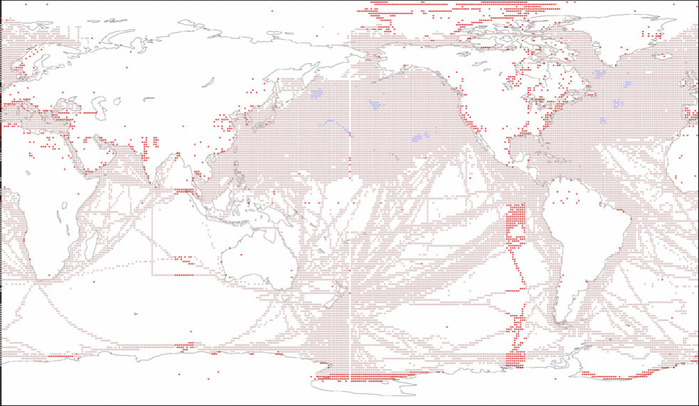
Figure 1. Deck 117 coverage for the period of record 1951-64 with the FOSDIC (red) version overlaid by the TD1100 (gray) and the Release 1 (blue) versions (i.e. the "pink" color shows the overlap, such that TD1100 is almost 100% duplicated in FOSDIC). There were no TD1100 data exactly on the 1-degree box straddling the dateline. The missing TD1100 data at 90-99°E/W longitudes were invalidly located at 190-199°E/W (those reports were therefore considered erroneous and not output from this translation, but could potentially be recovered via a longitude correction). Apparently landlocked reports were previously edited out of the TD1100 data.
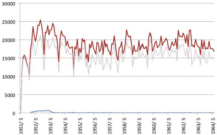
Figure 2. Number of reports per month in the DSI1117 (indigo), FOSDIC (red), TD1100 (gray), and Release 1 (blue) versions.
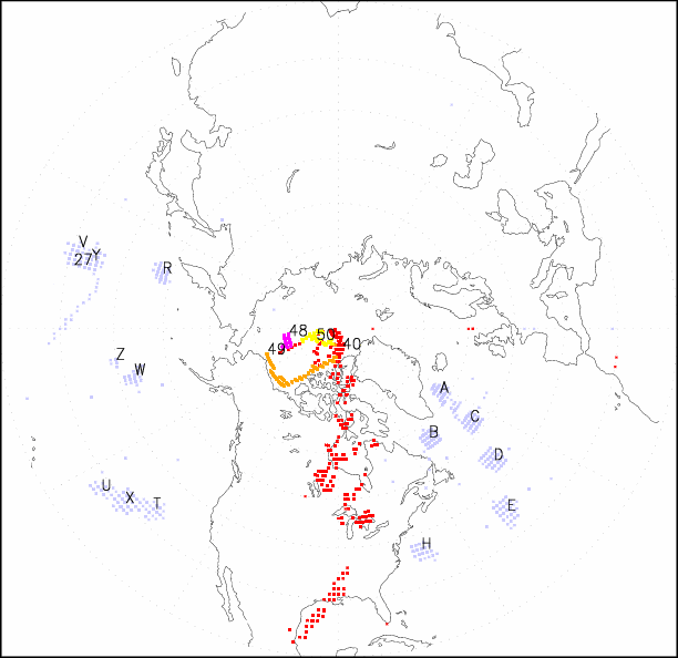
Figure 3. Spatial distribution of the Ocean Station Vessel (OSV) and ice island component of DSI1117, with individual ships plotted separately using a shortened ID number, i.e. into which the third and fourth digits of the original "ship number" field were extracted. Shortened numbers 01-26 have also been converted into a letter (A-Z) (see Fig. 4) because we noted that the first few of these correspond with historical Ocean Weather Station locations (i.e. A, B, C, D, E) (see Diaz et al. 1987). The red over North America corresponds to ship number 0040.
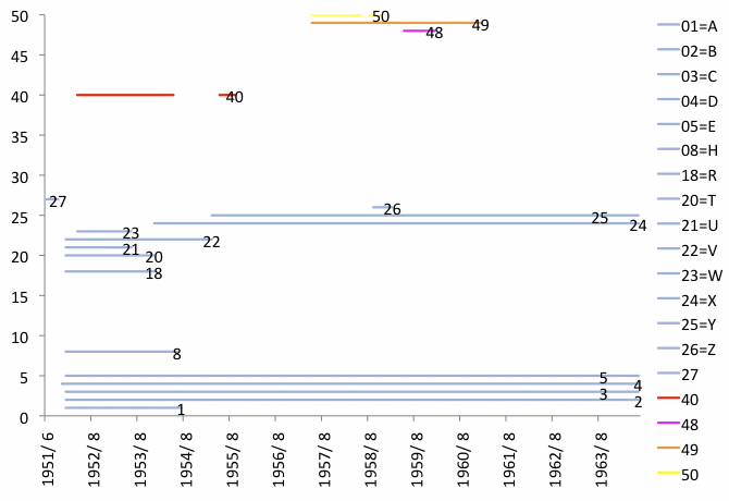
Figure 4. Temporal distribution of the Ocean Station Vessel (OSV) and ice island component of DSI1117, with individual ships plotted separately according to the shortened ID number with 01-26 converted to A-Z plotted in Fig. 3. For reasons discussed in the Fig. 3 caption, 01-27 have been assigned PT=3 (ocean station vessel--on station), and the remaining numbers 40, 48, 49, and 50 PT=9 (ice station). Ice island ship numbers were 40, 0040, 4848, 4949, and 5050 while the first two characters of OSV ship numbers varied across and within shortened ID numbers.
Additional ID notes:
The original ship number field is described in AWS-WB (1964) as:
"All ships have been assigned numbers beginning with 'X' in col. 1. The three following numbers in col. 2 thru 4 range from 001-999. Ship name and records available at NWRC."NCDC (2003) provides the same description, except omitting the last sentence. The original card deck 110 format contained a 3-digit ID described in AWS-WB (1958) as coded 0-999, and in addition as an
"Arbitrary number assigned to Navy ships. Whenever possible the ship's number was assigned in numerical sequence, according to the alphabetical arrangement of the ship's name."While as noted above deck 117 represents a continuation of deck 110, whether there is any relationship between their (effectively) 3-digit ship number systems (leaving aside the leading "X" in deck 117) is not known.
The remainder of this webpage discusses detailed field comparison results (Fig. 5) between AWS-WB (1964) and NCDC (1968) versions of deck 117, and the Annex provides selected further comparisons between the AWS-WB (1964) and Release 1 versions. While the FOSDIC and TD1100 data sources share some field characteristics (when duplicates are compared), other TD1100 fields did not appear to have been derived exclusively, or in a way that can be replicated, from the otherwise matching FOSDIC reports. As one possible cause, it appears that extensive quality control processing may have been applied to the TD1100 data, or possibly both were derived from a third source. As a consequence, for utilization in upcoming ICOADS updates, it may therefore be advisable to use an original card deck version of the data, unless NCDC is able to locate additional clarifications as to the origins of the TD1100 data, or e.g. original US Navy records (forms) can be checked to better resolve these questions.
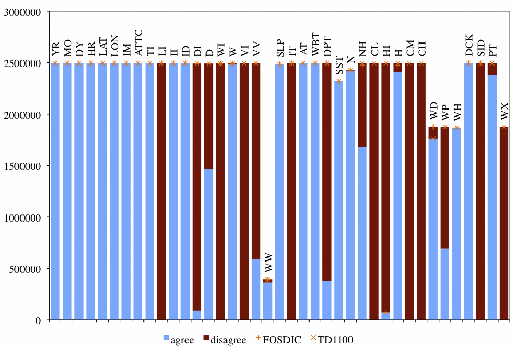
Figure 5. Element agreement and number non-missing. FOSDIC and TD1100 reports were considered duplicates if year (YR), month (MO), day (DY), hour (HR), latitude (LAT), longitude (LON), call sign (ID), sea level pressure (SLP), air temperature (AT), wet bulb temperature (WBT), and sea surface temperature (SST) agreed. 84.5995% of the FOSDIC and 99.6504% of the TD1100 reports were duplicates of each other.
2. Discussion of field disagreements (Fig. 5)
- lat lon indicator (LI)
- FOSDIC whole degrees versus TD1100 degrees and tenths. During Release 1 processing (ref. Slutz et al. 1985, Table K5-1) the tenths positions of latitude and longitude for deck 117 were adjusted from the corners (tenths positions 0,0) to the centers of 1-degree boxes (tenths positions 5,5). No such action has been taken yet on the FOSDIC or TD1100 data.
- wind direction indicator (DI)
- FOSDIC 16 of 32-point compass versus TD1100 16 of 36-point compass. AWS-WB (1964) states 36-point compass beginning in 1963, but it was not until 1964.
- wind direction (D)
- Incompatible compasses until 1964 (see DI).
- wind speed indicator (WI)
- FOSDIC knots, measured versus TD1100 knots, estimated.
- visibility indicator (VI)
- Only in TD1100.
- visibility (VV)
- FOSDIC nautical miles and fractions versus TD1100 code.
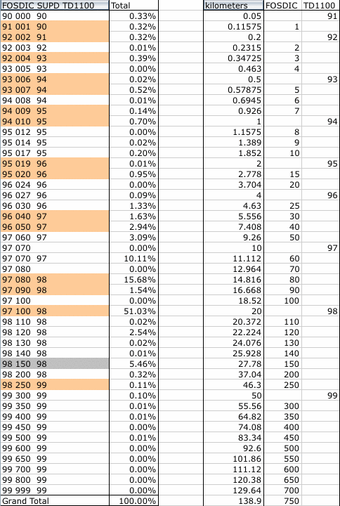
Table 1. Relative frequency of FOSDIC, together with FOSDIC supplemental data attachment (SUPD) columns 25-27 (see AWS-WB for fractions), versus TD1100 with disagreement highlighted in orange (left) and conversion of codes to kilometers (right). AWS-WB (1964) states that "150 (15.0 mi.) was punched when visibility 15+ was reported, indicating visibility greater than 15 miles without a checkpoint," but in this case 150 (highlighted in gray) was simply utilized as the FOSDIC data input value. Totals less than 10 not shown.
- present weather (WW)
- FOSDIC codes versus TD1100 code.
Table 2. Disagreement of present weather in descending order of frequency. Totals less than 10 not shown.FOS TD11 Total 12 10 17,523 12 = more or less continuous shallow fog or ice fog at the station, not deeper than about 10 meters. 10 = light fog (visibility 1,100 yards or more); synonymous with European term "mist." 5 4 6,902 5 = haze. 4 = visibility reduced by smoke. 7 36 4,049 7 = dust or sand raised by wind at or near the station at the time of observation, but no well-developed dust whirl(s) or sand whirl(s), and no duststorm or sandstorm seen; or, in the case of ships, blowing spray at the station 36 = slight or moderate drifting snow generally low (below eye level, less than 6 feet). 81 82 912 81 = rain shower, moderate or heavy. 82 = rain shower, violent. 81 95 859 81 = rain shower, moderate or heavy. 95 = thunderstorm, slight or moderate, without hail, but with rain and/or snow at time of observation. 80 95 590 80 = rain shower, slight. 95 = thunderstorm, slight or moderate, without hail, but with rain and/or snow at time of observation. 38 220 38 = slight or moderate blowing snow generally high (above eye level, 6 feet or more). = 79 87 79 = ice pellets, type (a) (sleet, U.S. definition). = 90 84 90 = moderate or heavy showers of hail, with or without rain or rain and snow, mixed, not associated with thunder. = 59 63 70 59 = drizzle and rain, moderate or heavy. 63 = rain, not freezing, continuous, moderate at time of observation. 69 71 58 69 = rain or drizzle and snow, moderate or heavy. 71 = continuous fall of snowflakes, slight at time of observation. 69 73 17 69 = rain or drizzle and snow, moderate or heavy. 73 = continuous fall of snowflakes, moderate at time of observation. 84 85 16 84 = shower of rain and snow mixed, moderate or heavy. 85 = snow shower, slight. 90 80 14 90 = moderate or heavy showers of hail, with or without rain or rain and snow, mixed, not associated with thunder. 80 = rain shower, slight. 90 81 13 90 = moderate or heavy showers of hail, with or without rain or rain and snow, mixed, not associated with thunder. 81 = rain shower, moderate or heavy. 59 61 13 59 = drizzle and rain, moderate or heavy. 61 = rain, not freezing, continuous, slight at time of observation. 96 95 12 96 = thunderstorm, slight or moderate, with hail at time of observation. 95 = thunderstorm, slight or moderate, without hail, but with rain and/or snow at time of observation. 79 63 12 79 = ice pellets, type (a) (sleet, U.S. definition). 63 = rain, not freezing, continuous, moderate at time of observation. 79 61 10 79 = ice pellets, type (a) (sleet, U.S. definition). 61 = rain, not freezing, continuous, slight at time of observation. 38 10 10 38 = slight or moderate blowing snow generally high (above eye level, 6 feet or more). 10 = light fog (visibility 1,100 yards or more); synonymous with European term "mist." - temperature indicator (IT)
- FOSDIC whole degrees Fahrenheit versus TD1100 degrees Celsius and tenths.
- dew point temperature (DPT)
- FOSDIC and TD1100 dew point temperatures assumed computed.
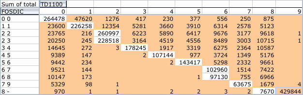
- lower cloud amount (NH)
- FOSDIC Cloud Amt. in 10ths 1st or lowest layer versus TD1100 oktas.
Table 3. Frequency of FOSDIC, together with FOSDIC SUPD column 50, versus TD1100 with disagreement highlighted in orange. The largest number in this mostly upper triangular table is outlined in blue.
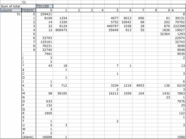
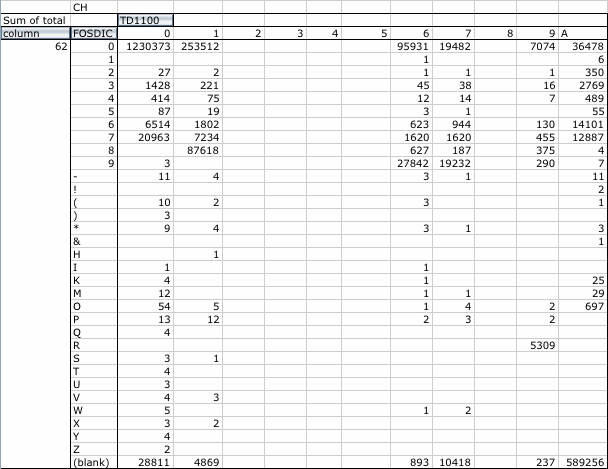
- cloud type (CL) (CM) (CH)
- Only in TD1100. FOSDIC code versus TD1100 code.
Table 4. No one-to-one correspondence between FOSDIC SUPD columns 51, 56, and 62 and TD1100.

- cloud height indicator (HI)
- FOSDIC HI set in the single case of cloud height of 888 (see H).
- cloud height (H)
- FOSDIC base of lowest layer in hundreds of feet versus TD1100 code.
AWS-WB (1964) states that "ceiling and height of ciriform clouds were punched as 888, when the ceiling and/or height of the cloud was a cirro type and the height was estimated" but in this case 888 was simply utilized as the FOSDIC data input value.
The most frequent disagreements together with FOSDIC SUPD columns 52-54 follow.
FOSDIC TD11 Total 5 020 9 102 3 008 9 104 2 003 9 116 9 --- 6 122 4 015 9 131 1 002 9 212 9 --- 2 219 0 000 9 223 3 230 2 005 9 232 8 249 0 001 9 264 5 295 4 010 9 324 9 --- 3 382 4 504 9 --- 8 550 9 --- 5 703 9 --- 4 850 2 003 1 9296 9 19263 9 080 8 46475 - wave direction (WD)
- Disagreement mostly FOSDIC waves confused, direction indeterminate versus TD1100 missing.
- wave period (WP)
- FOSDIC seconds versus TD1100 code.
- source id (SID)
- TD1100 140 versus FOSDIC 141 (an expected difference).
- platform type (PT)
- Only in TD1100 was ocean station vessel--on station identified among the US Navy or "deck" log, or unknown.
- wave period indicator (WX)
- Only in TD1100 (see WP).
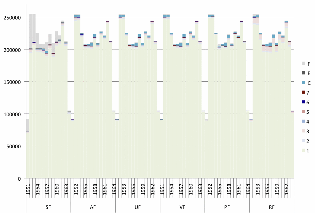
Figure 6. Number of reports per year in the FOSDIC version of deck 117, plotted separately to show the trimming flag value, within those reports, for these variables: SF = sea surface temperature, AF = air temperature, UF and VF = wind U and V components, PF = sea level pressure, RF = relative humidity. The trimming flags are defined as follows, where a1 is the individual observation under scrutiny, g is the smoothed median, and s1 and s5 are the smoothed lower and upper median deviation:
F = data missing or not computable
E = data unusable (SF, AF, and PF, only)
C = limits missing (ocean/coastal box)
7 = greater than 4.5 sigma upper limit (a1 > g + 4.5*s5)
6 = less than 4.5 sigma lower limit (a1 < g - 4.5*s1)
5 = greater than 3.5 sigma upper limit (g + 3.5*s5 < a1 <= g + 4.5*s5)
4 = less than 3.5 sigma lower limit (g - 4.5*s1 <= a1 < g - 3.5*s1)
3 = greater than 2.8 sigma upper limit (g + 2.8*s5 < a1 <= g + 3.5*s5)
2 = less than 2.8 sigma lower limit (g - 3.5*s1 <= a1 < g - 2.8*s1)
1 = within 2.8 sigma limits (g - 2.8*s1 <= a1 <= g + 2.8*s5)
Annex
Additional comparisons between the FOSDIC (SID=141) and Release 1 (SID=9) versions of deck 117. All these examples are from SID=9, OSV Supplement, which during Release 1 processing was converted from TD-1100 format.
                         A                                               W    D                              A A               DD
                L     L  T     N                               S   P     B   WP   D     S                    T TB  B    D  S   UU
   Y M D   H    A     O ITTLDV I I        I CD   W   V V WW    L   PI   AT   BT   P S   S NCH CC W W W S S S T TS  1 B  C  I P PPTPW
   R O Y   R    T     N MCIISS D I        D 1I  DI  WI V W1    PA  PT   TI   TI   T I   TNHLIHMH D P H D P H I LI  0 1  K  D T SCCBX
1952 9 9   0 2800 21500 0201     95721       3 684123 97   10221    6 222  189  172   22886  5   7 8 7       165      117141 0
1952 9 9   0 2850 21450 0201     95721       2 656123098   10221    0 222  189  172   22888105AA 7 9 7       165 23585117  9 3 0   1
1952 9 9 300 2800 21500 0201     95721       3 684123 97   10218    6 222  194  178   23985  5   7 8 6       165      117141 0
1952 9 9 300 2850 21450 0201     95721       2 656123098   10218    0 222  194  180   23988505AA 7 9 6       165 23585117  9 3 0   1
1952 9 9 600 2800 21500 0201     95721       3 684118 97   10238    6 222  189  172   24486  5   7 8 6       165      117141 0
1952 9 9 600 2850 21450 0201     95721       2 656118098   10238    0 222  189  172   24488505AA 7 9 6       165 23585117  9 3 0   1
1952 9 9 900 2800 21500 0201     95721       3 684103 9780 10241    6 211  189  178   22888  5    99         165      117141 0
1952 9 9 900 2850 21450 0201     95721       2 65610309880 10241    0 211  189  178   22889A05AA37 0         165 23585117  9 3 0   1
1952 9 91200 2800 21500 0201     95721       3 684 87 97   10227    6 217  189  172   23388  5    99         165      117141 0
1952 9 91200 2850 21450 0201     95721       2 656 87098   10227    0 217  189  176   23389A05AA37 0         165 23585117  9 3 0   1
1952 9 91500 2800 21500 0201     95721       3 684 82 97   10231    6 217  183  161   25062  5   7 8 5       165      117141 0
1952 9 91500 2850 21450 0201     95721       2 656 82098   10231    0 217  183  165   2506650500 7 9 5       165 23585117  9 3 0   1
1952 9 91800 2800 21500 0201     95721       3 684 98 97   10246    6 222  183  161   24461  5   6 6 6       165      117141 0
1952 9 91800 2850 21450 0201     95721       2 656 98098   10246    0 222  183  161   2446650500 6 7 6       165 23585117  9 3 0   1
1952 9 92100 2800 21500 0201     95721       3 684 98 98   10244    6 233  194  172   23311  5   6 8 6       165      117141 0
1952 9 92100 2850 21450 0201     95721       2 656 98098   10244    0 233  194  174   2331150500 6 9 6       165 23585117  9 3 0   1
1952 910   0 2800 21500 0201     95721       3 904 98 98   10233    6 228  194  178   23333  5   8 8 4       165      117141 0
1952 910   0 2850 21450 0201     95721       2 906 98098   10233    0 228  194  178   2333310500 8 9 4       165 23585117  9 3 0   1
1952 910 300 2800 21500 0201     95721       3 454 77 98   10224    6 217  183  167   24422  5   8 8 4       165      117141 0
1952 910 300 2850 21450 0201     95721       2 456 77098   10224    0 217  183  165   2442210500 8 9 4       165 23585117  9 3 0   1
1952 910 600 2800 21500 0201     95721       3 904 82 97   10233    6 217  189  172   24422  5   8 8 4       165      117141 0
1952 910 600 2850 21450 0201     95721       2 906 82098   10233    0 217  189  176   2442210500 8 9 4       165 23585117  9 3 0   1
1952 910 900 2800 21500 0201     95721       3 684 98 97   10236    6 222  194  172   24462  5   8 8 4       165      117141 0
1952 910 900 2850 21450 0201     95721       2 656 98098   10236    0 222  194  180   2446210550 8 9 4       165 23585117  9 3 0   1
1952 9101200 2800 21500 0201     95721       3 684 82 97   10221    6 217  189  172   24421  5   8 8 4       165      117141 0
1952 9101200 2850 21450 0201     95721       2 656 82098   10221    0 217  189  176   2442110550 8 9 4       165 23585117  9 3 0   1
1952 9101500 2800 21500 0201     95721       3 684 36 97   10216    6 217  189  172   24462  5   8 8 4       165      117141 0
1952 9101500 2850 21450 0201     95721       2 656 36098   10216    0 217  189  176   2446650500 8 9 4       165 23585117  9 3 0   1
1952 9101800 2800 21500 0201     95721       3 684 67 98   10227    6 222  200  189   23342  5   6 8 3       165      117141 0
1952 9101800 2850 21450 0201     95721       2 656 67098   10227    0 222  200  190   2334210550 6 9 3       165 23585117  9 3 0   1
1952 9102100 2800 21500 0201     95721       3 904 72 98   10225    6 233  194  178   23343  5   7 8 3       165      117141 0
1952 9102100 2850 21450 0201     95721       2 906 72098   10225    0 233  194  174   2334310550 7 9 3       165 23585117  9 3 0   1
1952 911   0 2800 21500 0201     95721       3 904 77 98   10213    6 228  200  183   23365  5   9 6 3       165      117141 0
1952 911   0 2850 21450 0201     95721       2 906 77098   10213    0 228  200  186   2336510550 9 7 3       165 23585117  9 3 0   1
1952 911 300 2800 21500 0201     95721       3 684 51 98   10203    6 222  194  189   23332  5   8 6 3       165      117141 0
1952 911 300 2850 21450 0201     95721       2 656 51098   10203    0 222  194  180   2333310500 8 7 3       165 23585117  9 3 0   1
1952 911 600 2800 21500 0201     95721       3 904 62 98   10217    6 222  200  189   23322  5  3899 3       165      117141 0
1952 911 600 2850 21450 0201     95721       2 906 62098   10217    0 222  200  190   2332210500   0 3       165 23585117  9 3 0   1
1952 911 900 2800 21500 0201     95721       3 904 46 97   10217    6 222  200  189   23322  5  3899 3       165      117141 0
1952 911 900 2850 21450 0201     95721       2 906 46098   10217    0 222  200  190   2332210500   0 3       165 23585117  9 3 0   1
1952 9111200 2800 21500 0201     95721       3 904 57 97   10213    6 222  200  189   22285  5  3899 3       165      117141 0
1952 9111200 2850 21450 0201     95721       2 906 57098   10213    0 222  200  190   22288505AA   0 3       165 23585117  9 3 0   1
1952 9111500 2800 21500 0201     95721       3 904 51 98   10208    6 222  200  189   23362  5   8 6 2       165      117141 0
1952 9111500 2850 21450 0201     95721       2 906 51098   10208    0 222  200  190   2336650500 8 7 2       165 23585117  9 3 0   1
1952 9111800 2800 21500 0201     95721       3 904 46 98   10223    6 228  189  167   23362  5   8 6 2       165      117141 0
1952 9111800 2850 21450 0201     95721       2 906 46098   10223    0 228  189  169   2336650500 8 7 2       165 23585117  9 3 0   1
1952 9112100 2800 21500 0201     95721       3 904 51 98   10225    6 233  200  183   23372  5   8 8 4       165      117141 0
1952 9112100 2850 21450 0201     95721       2 906 51098   10225    0 233  200  185   2337750500 8 9 4       165 23585117  9 3 0   1
References
AWS-WB (Air Weather Service and Weather Bureau), 1957: Reference Manual 117: Navy Marine Surface Observations 1951-. HQ, Air Weather Service, Data Control Div., and Weather Bureau, Climatological Services Div. (September 1957), 3 pp. (pdf; 226KB)
AWS-WB (Air Weather Service and Weather Bureau), 1958: Reference Manual 110: Navy Marine Surface Obs (WBAN 11). HQ, Air Weather Service, Weather Bureau, Clim. and Hydro. Services (revised 30 June 1958), 3 pp. (pdf; 390KB)
AWS-WB (Air Weather Service and Weather Bureau), 1964: Reference Manual 117: Navy Marine Surface Observations 1951-6/63. HQ, Air Weather Service, Data Control Div., and Weather Bureau, Climatological Services Div. (Revised September 1964), 3 pp. (pdf; 260KB)
Diaz, H.F., C.S. Ramage, S.D. Woodruff, and T.S. Parker, 1987: Climatic Summaries of Ocean Weather Stations. NOAA Environmental Research Laboratories, Climate Research Division, Boulder, CO, 363 pp. (pdf; 13.2MB)
Elms, J.D., S.D. Woodruff, S.J. Worley, and C. Hanson, 1993: Digitizing Historical Records for the Comprehensive Ocean-Atmosphere Data Set (COADS). Earth System Monitor, 4(2), 4-10 (html version)
Greenough, M.L.,1998: Report on Conversion of NCDC Microfilms to Electronic Files with FOSDIC. Greenough Data Associates, Rockville, MD. (pdf; 8MB)
NCDC (National Climatic Data Center), 1968: TDF-11 Reference Manual. NCDC, Asheville, NC, 138 pp. (pdf; 2.5MB)
NCDC (National Climatic Data Center), 2003: Data Documentation for Dataset 1117 (DSI-1117): Navy/Marine Surface Observations (November 17, 2003). (pdf; 42KB) [NCDC version of AWS-WB 1964]
Slutz, R.J., S.J. Lubker, J.D. Hiscox, S.D. Woodruff, R.L. Jenne, D.H. Joseph, P.M. Steurer, and J.D. Elms, 1985: Comprehensive Ocean-Atmosphere Data Set; Release 1. NOAA Environmental Research Laboratories, Climate Research Program, Boulder, CO, 268 pp. (NTIS PB86-105723) (html version)
[Documentation and Software][Links to additional]
U.S. National Oceanic and Atmospheric Administration hosts the icoads website privacy disclaimer
Document maintained by icoads@noaa.gov
Updated: Jul 25, 2012 18:06:59 UTC
http://www.icoads.noaa.gov/deck117.html